Sunday, December 8, 2013

The Top three software that you must learn to apply GIS

Recently the Water Resources and hydro power portal published a list of software that you must learn if you want to apply the advantage of GIS and Remote Sensing in your project.

The list was not extensive but selective.

While preparing the list the following factors were given weightage of importance where the first factor was given the highest importance and last one the opposite:

1.Ease of Use
2.Price in INR
3.Support
4.Features
5.Frequency of use in related problems
6.Number of Updates per Year
7.Probability of Bugs

The list can be seen in Baipatra home page.

Sunday, June 30, 2013

Research Ideas on Water Reuse


(Image Source)

The "Impact of Urbanization on Water Reuse Potential" and "Water Reuse Potential of Hydro-Power plant" can be two of the most important topic of research  related to water reuse.

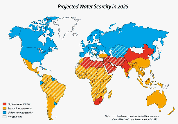
In the first topic the urbanization impact on Water Reuse Potential(WRP) is estimated.As world wide rapid urbanization is going on, the stress on "available water" of any region is immense.Due to the uneven distribution of water resources the problem is more acute where concentration of population is high but availability of water is low.According to Falkenmark's Water Stress Indicator,a region is said to be water scarce if per capita water availability is less than 5000cubicm.

Again availability of water will imply not only the quantity but also the quality of water available.The water must be qualitatively suitable for consumption.Otherwise, it will not be added to water resources potential of a region.

Due to urbanization there is an immense stress on this "available water".That is why mitigation measures like recycling water is given a lot of importance so that this increased population can be sustained and their demand for water can be somewhat satisfied.

But amount of water available for consumption is constant.Thus the supplied water must be recycled or reused.Hence,the interrelationship between rate of urbanization and WRP will be an interesting aspect to determine.The potential of urban population in degrading the quality of water is also another potential area of research which can enlighten us to determine the amount of water we have and can reclaim for reuse,

The second topic,the potential of water reuse in a hydro power plant will help to install a zero discharge hydro power plant which will be beneficial for both water as well as energy conservation of a region.In the study one objective will be to find the amount of water available for reuse.

Another aspect will be to determine the types of use that can be carried out with the reused water.Actual potential of water reuse can be given by a weighted index of all the purposes of water reuse.Each of the purposes can be weighted with respect to each other following some Multi-Criteria Decision Making approaches.

Once the amount of the water that can be reused for specific purposes are known,it can be multiplied by the weightage of the same purpose and total of the product of weights of all the purposes and available water for that purposes can be used to determine the WRP Index of the hydropower plant.

The index can represent the exact WRP of the plant in terms of the potential of the reused water to mitigate the demand of the plant intself.

Monday, May 13, 2013

New Research Idea : Selection of Conceptual Hydrologic Models for Estimating Runoff from Arid Watersheds


Abstract : 

The selection of ideal conceptual hydrologic model for prediction of surface runoff from any type of watershed is useful for the estimation of future hydrologic conditions of the basin.The predicted runoff is also important for design of hydraulic structure,preparation of watershed management plans ,disaster management etc. related activities.The future runoff will give an idea of future uncertainties that may trouble the watershed and its inhabitants.The hydrologic models which follows the basic physical laws of water balance to estimate the desired output cannot exactly estimate the runoff.There will be some differences with the actual situation and the predicted one.The deviations between the two is allowable but to a certain extent.There are many factors for this deviation.Some models are suitable for some specific types of watersheds.The availability of required dataset is also another important issue.The equalizing constants that are used to linearize interrelationships are also a factor for the error produced by the hydrologic model.That is why  selection of a suitable hydrologic model which can estimate at a desired accuracy under the restrictions imposed by the study watershed  and dataset availability is important for successful execution of projects involving runoff predictions.The present study tries to select a suitable hydrologic model based on the related factors and decision making algorithms for predicting surface runoff from an arid watershed.The decision making algorithms are popular for their impartial and scientific decision making based on historical,social and expert inputs.The advancements of such algorithms can be utilized to select an ideal hydrologic model which can minimize the error between the predicted and actual output.

Tools Utilized : AHP and Fuzzy,various hydrologic models

Keywords : hydrologic models,decision making algorithms,arid watershed.

Monday, April 15, 2013

Baipatra: Fractal Analysis

Baipatra: Fractal Analysis: Fractal Analysis is a relatively new concept for spatial analysis of a data pattern. Mainly used in detection of set of features in an im...

Saturday, March 23, 2013

Calculator of Design Factors of Pump Storage Plant

Different design factors of Pump Storage Plant can be calculated with the following software.

The software can help students,researchers,engineers to calculate the specific speed,submergence,Potential of Cavitation in the flow and efficiency of pumped storage plants along with the L/h ratio to find the economic requirements of the plant if Normal Speed,Generation and Pump Efficiency,frequency factor,gross head are known.

The Software can calculate :

Specific Speed from Normal Speed,Discharge and Gross Head
Submergence from Specific Speed and head
Overall Efficiency of Pumped Storage Plant from Generator and Pump Efficiency,k value,Gross Head and Discharge.
Potential of Cavitation is estimated from Critical Cavitation,Effective,Suction and Barometric head of water.
The economic requirements of the pumped storage plant can be estimated from dividing Length of Tail Race by Effective Head.Lesser is the ration more economical will be the Pump Storage Plant.

Calculate

Potential of KVL,KCL and Graph Theory for Finding loss in Pipe Networks

To find the loss of pressure or flow within a pipeline we can use the concept of graph theory and Mason Gain Formula where gain can be equivalent to flow resistance.

Kirchoff's Current and Voltage Law can also be used to solve pipe line problems where Voltage can be replaced by Tanks/Reservoirs,resistance by friction loss and current with flow of water.

The circuit losses like capacitance can be compared to surge tanks and inductance may be replaced by the eddy flows which often causes the hammering in the pipeline.

Such methods can easily determine the value of losses within a pipeline if flow and potential is known or vice-versa and necessary scale corrections are applied without the requirements of data and knowledge of computations.

Tuesday, March 12, 2013

Importance of Coordinate Systems in GIS

The first step in developing an interactive map linked to relevant data that you want to represent is to select the coordinate system with which you want to work.The tip is if you are working in a global scale use the global coordinate systems.

If you are working within a country use the local coordinate systems.If the scale of you work is within the district/state then use cadastral maps.

A single point can be represented by x and y axis of your paper,height and width of your room or even the global coordinate systems.Each of the representation will be correct but the resolution will be effected.In x and y axis of your paper the resolution will be best,in the height and width of your room resolution will be medium and in the global axis it will be poor.

That is why there are various types of coordinate systems and they are utilized based on the spatial scale at which you are working.